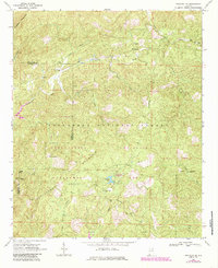
1967 Map of Piedmont SE
USGS Topo · Published 1985About this map
Talladega National Forest dominates this section of the Alabama landscape, where the ridges of Dugger Mountain and Rattlesnake Mountain shape the local topography. This 1960s survey, updated with revisions from the early 1980s, highlights the development of the Choccolocco Wildlife Management Area. Recreational and administrative infrastructure is visible at the Choccolocco Ranger Station and the Coleman Lake Campground and Picnic Area, while the rugged peaks are navigated by the Skyway Motorway and Pinkoti Trail.
Find a feature on this map
28 named features on this map. Tap any name to fly to it.
Don’t see what you’re looking for? This feature index may not catch every label — zoom into the map to look around manually.
Map Details
Editions of this 1967 Piedmont SE Map
2 editions found
Other maps of this area

1889 · Tallapoosa
USGS Topo · 1:125,000

1892 · Tallapoosa
USGS Topo · 1:125,000

1897 · Tallapoosa
USGS Topo · 1:125,000

1900 · Anniston
USGS Topo · 1:125,000

1953 · Atlanta
USGS Topo · 1:250,000

1954 · Choccolocco
USGS Topo · 1:24,000

1957 · Atlanta
USGS Topo · 1:250,000

1958 · Atlanta
USGS Topo · 1:250,000
1966 · Borden Springs
USGS Topo · 1:24,000
1966 · Oak Level
USGS Topo · 1:24,000