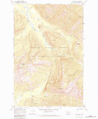
1970 Map of Pilot Peak
USGS Topo · Published 1983About this map
Bob Marshall Wilderness and the Flathead National Forest dominate this 1970 study of a remote Montana interior. The landscape is defined by the drainage systems of the South Fork Flathead River, which is fed by numerous tributaries including Danaher Creek and Youngs Creek. This map documents a network of traditional travel routes, such as the Pack Trail and Catchem Trail, which were essential for managing these protected lands before modern road development.
Find a feature on this map
34 named features on this map. Tap any name to fly to it.
Don’t see what you’re looking for? This feature index may not catch every label — zoom into the map to look around manually.
Map Details
Editions of this 1970 Pilot Peak Map
2 editions found
Other maps of this area

1902 · Ovando
USGS Topo · 1:125,000

1905 · Ovando
USGS Topo · 1:125,000

1936 · Silvertip
USGS Topo · 1:96,000

1942 · Silvertip
USGS Topo · 1:125,000

1955 · Choteau
USGS Topo · 1:250,000

1957 · Choteau
USGS Topo · 1:250,000

1958 · Choteau
USGS Topo · 1:250,000

1962 · Choteau
USGS Topo · 1:250,000
1970 · Crimson Peak
USGS Topo · 1:24,000
1970 · Danaher Mountain
USGS Topo · 1:24,000