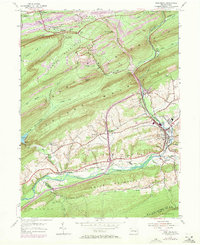
1954 Map of Pine Grove
USGS Topo · Published 1971About this map
The Reading railroad network dominates the landscape of this Schuylkill County region, threading through narrow gaps in Broad Mountain and Second Mountain to serve the coal industry. In the southern valley, the settlement of Pine Grove sits at the confluence of several vital routes, surrounded by smaller communities such as Ravine, Paradise, and Suedberg. The presence of Industrial Waste Ponds and numerous Mines in the northern heights near Lorberry contrasts with the agricultural and residential character of the lower elevations.
Find a feature on this map
63 named features on this map. Tap any name to fly to it.
Don’t see what you’re looking for? This feature index may not catch every label — zoom into the map to look around manually.
Map Details
Editions of this 1954 Pine Grove Map
4 editions found
Other maps of this area

1891 · Lebanon
USGS Topo · 1:62,500

1892 · Lykens
USGS Topo · 1:62,500

1892 · Hummelstown
USGS Topo · 1:62,500

1892 · Pine Grove
USGS Topo · 1:62,500

1893 · Lykens
USGS Topo · 1:62,500

1893 · Lebanon
USGS Topo · 1:62,500

1899 · Lebanon
USGS Topo · 1:62,500

1924 · Hummelstown
USGS Topo · 1:62,500

1943 · Lebanon
USGS Topo · 1:62,500

1943 · Lykens
USGS Topo · 1:62,500
Featured Places
- Bethel Township, PA
- Hegins Township, PA
- Pine Grove, Pine Grove Township
- Union Township, PA
- Tremont Township, PA