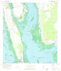
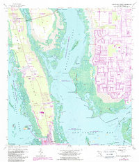
1958 Map of Pine Island Center
USGS Topo · Published 1973About this map
Pine Island and the intricate mangroved waterways of Matlacha Pass are documented here during a period of transition in the late 1950s, with later updates reflecting early 1970s development. The settlement at Pine Island Center and the fishing village of Matlacha anchor the northern reaches, while the southern tip features St James City and the engineered waters of the Monroe Canal and Dawson Canal. This survey illustrates the specialized coastal infrastructure of the era, from the numerous Flowing Wells scattered across the island to the protected boundaries of the Matlacha Pass National Wildlife Refuge. The landscape is a complex network of named keys and points, such as Starvation Key and Reckems Point, situated where the Caloosahatchee River meets San Carlos Bay.
Find a feature on this map
60 named features on this map. Tap any name to fly to it.
Don’t see what you’re looking for? This feature index may not catch every label — zoom into the map to look around manually.
Map Details
Editions of this 1958 Pine Island Center Map
6 editions found

Other maps of this area

1956 · West Palm Beach
USGS Topo · 1:250,000

1956 · Tampa
USGS Topo · 1:250,000

1956 · Charlotte Harbor
USGS Topo · 1:250,000

1957 · West Palm Beach
USGS Topo · 1:250,000

1958 · West Palm Beach
USGS Topo · 1:250,000

1958 · Matlacha
USGS Topo · 1:24,000

1958 · Captiva
USGS Topo · 1:24,000

1958 · Fort Myers NW
USGS Topo · 1:24,000

1958 · Fort Myers SW
USGS Topo · 1:24,000

1958 · Sanibel
USGS Topo · 1:24,000