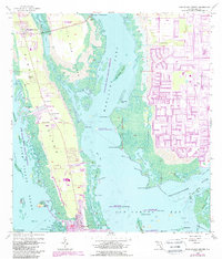
1958 Map of Pine Island Center
USGS Topo · Published 1988About this map
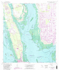
Pine Island and the surrounding aquatic preserves characterize this coastal Florida landscape, where a transition from rural island life to suburban development is underway. To the west, Pine Island Sound and numerous smaller keys like Regla Island and Chino Island suggest a long-established maritime environment. Along the island's spine, St James City and Pine Island Center serve as primary hubs, while smaller landing spots like Masters Landing and residential pockets at Flamingo Bay dot the shoreline.
Find a feature on this map
65 named features on this map. Tap any name to fly to it.
Don’t see what you’re looking for? This feature index may not catch every label — zoom into the map to look around manually.
Map Details
Editions of this 1958 Pine Island Center Map
6 editions found

Other maps of this area

1956 · West Palm Beach
USGS Topo · 1:250,000

1956 · Tampa
USGS Topo · 1:250,000

1956 · Charlotte Harbor
USGS Topo · 1:250,000

1957 · West Palm Beach
USGS Topo · 1:250,000

1958 · West Palm Beach
USGS Topo · 1:250,000

1958 · Matlacha
USGS Topo · 1:24,000

1958 · Captiva
USGS Topo · 1:24,000

1958 · Fort Myers NW
USGS Topo · 1:24,000

1958 · Fort Myers SW
USGS Topo · 1:24,000

1958 · Sanibel
USGS Topo · 1:24,000