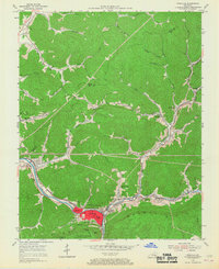
1954 Map of Pineville
USGS Topo · Published 1967About this map
Pineville serves as the focal point of this mid-century survey, situated at a strategic gap where the Cumberland River cuts through the formidable ridge of Pine Mountain. The settlement pattern reflects the industrial and educational needs of the era, featuring clustered communities like Arjay and Straight Creek along the narrow valley floors. Transportation is dominated by the Louisville and Nashville railroad lines that follow the river and creeks to serve the region's extraction and commerce. Local history is deeply embedded in the map's numerous community institutions, including the County High Sch, Lone Jack Sch, and Dorton Branch Sch, alongside landmarks like Chain Rock within Pine Mountain State Park. Signs of local industry are evident in the strip mine areas and scattered gas wells in the northern hills near Stinking Creek.
Find a feature on this map
62 named features on this map. Tap any name to fly to it.
Don’t see what you’re looking for? This feature index may not catch every label — zoom into the map to look around manually.
Map Details
Editions of this 1954 Pineville Map
2 editions found
Other maps of this area

1886 · Cumberland Gap
USGS Topo · 1:125,000

1888 · Cumberland Gap
USGS Topo · 1:125,000

1891 · Cumberland Gap
USGS Topo · 1:125,000

1903 · Pineville
USGS Topo · 1:48,000

1903 · Middlesboro
USGS Topo · 1:48,000

1927 · Middlesboro
USGS Topo · 1:62,500

1930 · Middlesboro
USGS Topo · 1:62,500

1935 · Varilla
USGS Topo · 1:24,000

1952 · Fount
USGS Topo · 1:24,000
1952 · Artemus
USGS Topo · 1:24,000