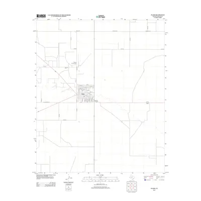
2012 Map of Plains
USGS Topo · Published 2012About this map
Plains serves as the central hub of this West Texas landscape, showing the organized street grid of the town as it appeared in the early 21st century. The map reveals a town structure defined by numbered streets from 1st St to 17th St, intersected by alphabetically named thoroughfares such as Avenue A and Avenue E. To the northwest, the Plains Oil Field indicates the industrial energy footprint essential to this region, while the Yoakum County Airport sits just north of the residential center, accessible via Airport Rd. The surrounding territory is carved into a precise grid of rural roads, including Whiskey Rd and Poindexter Rd, which facilitate transport across the high plains. This map captures the intersection of traditional West Texas ranching country with modern infrastructure and petroleum extraction.
Find a feature on this map
36 named features on this map. Tap any name to fly to it.
Don’t see what you’re looking for? This feature index may not catch every label — zoom into the map to look around manually.
Map Details
Editions of this 2012 Plains Map
This is the sole edition of this map. No revisions or reprints were ever made.
Other maps of this area

1954 · Brownfield
USGS Topo · 1:250,000

1958 · Brownfield
USGS Topo · 1:250,000

1962 · Brownfield
USGS Topo · 1:250,000

1970 · Plains 1 SW
USGS Topo · 1:24,000

1970 · Tokio NW
USGS Topo · 1:24,000

1970 · Pleasant Hill
USGS Topo · 1:24,000

1971 · Plains NW
USGS Topo · 1:24,000
1971 · Ink Basin
USGS Topo · 1:24,000
1971 · Plains SE
USGS Topo · 1:24,000
1971 · Plains
USGS Topo · 1:24,000