
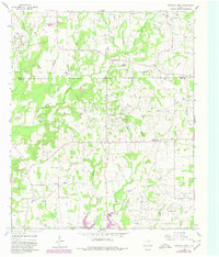
1960 Map of Pleasant Grove
USGS Topo · Published 1962About this map
The oil fields of East Texas define this 1960 landscape across the Hopkins Co Wood Co line. Extensive drilling operations are visible through the Como Field, Coke Oil Field, and Manziel Oil Field, indicating a period of significant extraction and industrial activity. Amidst the network of wells and pipelines, the rural social fabric remains rooted in small settlements like Pleasant Grove and Pickton.
Find a feature on this map
25 named features on this map. Tap any name to fly to it.
Don’t see what you’re looking for? This feature index may not catch every label — zoom into the map to look around manually.
Map Details
Editions of this 1960 Pleasant Grove Map
2 editions found
Other maps of this area

1953 · Texarkana
USGS Topo · 1:250,000

1956 · Texarkana
USGS Topo · 1:250,000

1956 · Tyler
USGS Topo · 1:250,000

1959 · Calvary
USGS Topo · 1:24,000

1959 · Yantis
USGS Topo · 1:24,000

1959 · Alba
USGS Topo · 1:62,500

1960 · Winnsboro
USGS Topo · 1:24,000

1960 · Cartwright
USGS Topo · 1:24,000

1960 · Quitman
USGS Topo · 1:24,000

1964 · Como
USGS Topo · 1:24,000