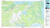
1985 Map of Plymouth
USGS Topo · Published 1990About this map
The Roanoke River meets the waters of Albemarle Sound near the town of Plymouth, serving as a gateway to the vast wetlands of eastern North Carolina. This mid-1980s landscape is defined by extensive wildlife conservation areas and state lands, including Pettigrew State Park and the Pungo National Wildlife Refuge. Large water bodies like Phelps Lake, New Lake, and the northern reaches of Lake Mattamuskeet dominate the interior, while the Scuppernong River and Alligator River create a complex network of drainage through the surrounding pocosin and swamp land. The map reveals a transition in land use, showing industrial waste ponds and Prison Unit 460 alongside rural settlements like Wenona and Mackeys. Transport infrastructure is anchored by the Norfolk Southern railroad and several state highways, connecting smaller crossroads such as Pantego, Roper, and Columbia.
Find a feature on this map
160 named features on this map. Tap any name to fly to it.
Don’t see what you’re looking for? This feature index may not catch every label — zoom into the map to look around manually.
Map Details
Editions of this 1985 Plymouth Map
2 editions found
Other maps of this area

1901 · Williamston
USGS Topo · 1:62,500

1902 · Williamston
USGS Topo · 1:62,500

1902 · Vanceboro
USGS Topo · 1:62,500

1903 · Chocowinity
USGS Topo · 1:62,500

1904 · Edenton
USGS Topo · 1:62,500

1904 · Vanceboro
USGS Topo · 1:62,500

1905 · Chocowinity
USGS Topo · 1:62,500

1905 · Vanceboro
USGS Topo · 1:62,500

1906 · Hertford
USGS Topo · 1:62,500

1914 · Belhaven
USGS Topo · 1:48,000