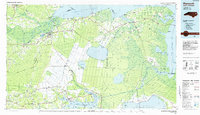
1985 Map of Plymouth
USGS Topo · Published 1985About this map
Phelps Lake and the surrounding pocosin terrain dominate this mid-1980s landscape at the edge of the Albemarle Sound. The area is defined by massive tracts of conserved wetlands and refuge lands, including Pettigrew State Park, the Pungo National Wildlife Refuge, and a portion of the Mattamuskeet National Wildlife Refuge. While Plymouth serves as a primary hub near the Roanoke River, much of the interior is shaped by the complex drainage networks of Morgan Swamp and Hollow Ground Swamp.
Find a feature on this map
151 named features on this map. Tap any name to fly to it.
Don’t see what you’re looking for? This feature index may not catch every label — zoom into the map to look around manually.
Map Details
Editions of this 1985 Plymouth Map
2 editions found
Other maps of this area

1901 · Williamston
USGS Topo · 1:62,500

1902 · Williamston
USGS Topo · 1:62,500

1902 · Vanceboro
USGS Topo · 1:62,500

1903 · Chocowinity
USGS Topo · 1:62,500

1904 · Edenton
USGS Topo · 1:62,500

1904 · Vanceboro
USGS Topo · 1:62,500

1905 · Chocowinity
USGS Topo · 1:62,500

1905 · Vanceboro
USGS Topo · 1:62,500

1906 · Hertford
USGS Topo · 1:62,500

1914 · Belhaven
USGS Topo · 1:48,000