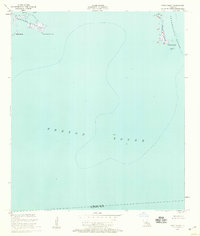
1955 Map of Point Chicot
USGS Topo · Published 1959About this map
Chandeleur Sound and Breton Sound meet in this mid-century maritime survey, illustrating the isolated marsh islands and coastal waters of St. Bernard Parish. The chart highlights the narrow, elongated profile of Chicot Island, which is separated from the mainland by Chicot Pass. Navigational markers such as the Point Chicot Light and a lone Beacon indicate the vital shipping routes through these shallow waters. To the northwest, the map captures the fragmented shoreline of Deadman Island and the nearby Grass Island within Eloi Bay. This document is a precise record of the Louisiana coastline before significant twentieth-century erosion and subsiding modified these barrier features, showing the exact position of landforms like Deadman Point and the parish boundary between St. Bernard Parish and Plaquemines Parish.
Find a feature on this map
12 named features on this map. Tap any name to fly to it.
Don’t see what you’re looking for? This feature index may not catch every label — zoom into the map to look around manually.
Map Details
Editions of this 1955 Point Chicot Map
2 editions found
Other maps of this area

1893 · La Fortuna
USGS Topo · 1:62,500

1893 · Chandeleur
USGS Topo · 1:62,500

1895 · Bodreau
USGS Topo · 1:62,500

1935 · Morgan Harbor
USGS Topo · 1:31,680

1935 · Lake Athanasio
USGS Topo · 1:31,680
1947 · Lake Athanasio
USGS Topo · 1:31,680
1947 · Lake Eloi
USGS Topo · 1:31,680
1954 · Morgan Harbor
USGS Topo · 1:31,680
1954 · Lake Eloi
USGS Topo · 1:31,680
1955 · Morgan Harbor
USGS Topo · 1:24,000