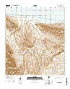
2014 Map of Point Hope D-2 SE
USGS Topo · Published 2014About this map
The Chukchi Sea coastline defines the northern edge of this remote Arctic landscape, where the tides meet a narrow coastal strip before giving way to the interior elevations. The hydrology of the region is dominated by the Ayugatak Lagoon and the winding course of Ayugatak Cr, which drains a significant portion of the surrounding highlands. These heights include the Igrarok Hills in the west and the Ayugatak Hills to the east, providing a clear view of the drainage patterns essential for navigating this roadless terrain. Collected by the U.S. Geological Survey, the topographic data illustrates the transition from saltwater maritime environments to the rising slopes of the North Slope. This 2014 survey serves as a precise record of the shoreline and elevation contours in a part of Alaska where the relationship between the sea and the coastal tundra is constantly shifting.
Find a feature on this map
10 named features on this map. Tap any name to fly to it.
Don’t see what you’re looking for? This feature index may not catch every label — zoom into the map to look around manually.
Map Details
Editions of this 2014 Point Hope D-2 SE Map
This is the sole edition of this map. No revisions or reprints were ever made.
Other maps of this area

1952 · Point Hope
USGS Topo · 1:250,000

1952 · Point Hope D-1
USGS Topo · 1:63,360

1952 · Point Hope D-2
USGS Topo · 1:63,360

1955 · Point Hope
USGS Topo · 1:250,000

1955 · Point Hope C-1
USGS Topo · 1:63,360

1955 · Point Hope C-2
USGS Topo · 1:63,360

1965 · Point Hope
USGS Topo · 1:250,000
2014 · Point Hope C-1 NW
USGS Topo · 1:25,000
2014 · Point Hope D-2 NW
USGS Topo · 1:25,000
2014 · Point Hope D-2 SW
USGS Topo · 1:25,000