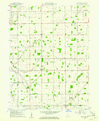
1960 Map of Point Isabel
USGS Topo · Published 1973About this map
The agrarian landscape of central Indiana is defined by a dense grid of drainage ditches and county roads in this early 1960s survey. The settlement of Point Isabel sits at the intersection of these productive lands, surrounded by local institutions like the Township Sch and Jones Chapel. The map reveals a high concentration of water management features essential to the region's farming economy, including Wimmer Ditch, Roberts Ditch, and Harper Ditch. These man-made channels support the natural flow of Pipe Creek and the Middle Fork of Wildcat Creek. Toward the southern boundary, the village of Rigdon straddles the line near the Rigdon Cem, illustrating the small-town clusters that served as social hubs for the surrounding farmsteads. Genealogical details are preserved through numerous named burial grounds and rural houses of worship, such as Knox Chapel Cemetery and Antioch Ch.
Find a feature on this map
51 named features on this map. Tap any name to fly to it.
Don’t see what you’re looking for? This feature index may not catch every label — zoom into the map to look around manually.
Map Details
Editions of this 1960 Point Isabel Map
4 editions found
Other maps of this area

1953 · Muncie
USGS Topo · 1:250,000

1956 · Muncie
USGS Topo · 1:250,000

1960 · Elwood
USGS Topo · 1:24,000

1960 · Point Isabel
USGS Topo · 1:24,000

1960 · Alexandria
USGS Topo · 1:24,000

1960 · Fairmount
USGS Topo · 1:24,000

1960 · Windfall
USGS Topo · 1:24,000

1960 · Greentown
USGS Topo · 1:24,000

1961 · Marion
USGS Topo · 1:24,000
1962 · Amboy
USGS Topo · 1:24,000