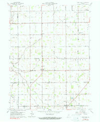
1960 Map of Point Isabel
USGS Topo · Published 1983About this map
Point Isabel serves as a central hub in this agricultural landscape at the intersection of Grant, Howard, Tipton, and Madison counties. The mid-century rural character is defined by a dense network of drainage ditches, such as Wimmer Ditch and Sims Franklin Ditch, which converted the wet prairie into productive farmland. Small community anchors like Antioch Ch and the Township Sch illustrate the social fabric of the era, while the Nyc & St L railroad corridor and a legacy Railroad Grade trace the historical transportation routes that once linked these isolated hamlets.
Find a feature on this map
39 named features on this map. Tap any name to fly to it.
Don’t see what you’re looking for? This feature index may not catch every label — zoom into the map to look around manually.
Map Details
Editions of this 1960 Point Isabel Map
4 editions found
Other maps of this area

1953 · Muncie
USGS Topo · 1:250,000

1956 · Muncie
USGS Topo · 1:250,000

1960 · Elwood
USGS Topo · 1:24,000

1960 · Point Isabel
USGS Topo · 1:24,000

1960 · Alexandria
USGS Topo · 1:24,000

1960 · Fairmount
USGS Topo · 1:24,000

1960 · Windfall
USGS Topo · 1:24,000

1960 · Greentown
USGS Topo · 1:24,000

1961 · Marion
USGS Topo · 1:24,000
1962 · Amboy
USGS Topo · 1:24,000