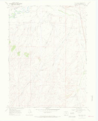
1969 Map of Pole Gulch
USGS Topo · Published 1972About this map
The Little Snake River winds through the northern reaches of this Moffat County landscape, accompanied by a network of drainage systems that define the area's geography. This late 1960s survey documents a region where ranching and natural resource extraction intersect, evidenced by the presence of an Oil Well and a Drill Hole near Pole Gulch. The terrain is deeply inscribed by seasonal watercourses like Timberlake Creek, Fourmile Creek, and Gledhill Draw, while a significant Pipeline cuts across the western and eastern sections, signaling the industrial infrastructure of the era. Settlement is sparse, with the map focusing on the physical relief of the high desert and the essential water sources, including a Spring located at the head of a nameless canyon near Thornburgh Gulch.
Find a feature on this map
11 named features on this map. Tap any name to fly to it.
Don’t see what you’re looking for? This feature index may not catch every label — zoom into the map to look around manually.
Map Details
Editions of this 1969 Pole Gulch Map
3 editions found
Other maps of this area

1916 · Craig
USGS Topo · 1:125,000

1954 · Rawlins
USGS Topo · 1:250,000

1954 · Craig
USGS Topo · 1:250,000

1957 · Craig
USGS Topo · 1:250,000

1957 · Baggs
USGS Topo · 1:62,500

1958 · Rawlins
USGS Topo · 1:250,000

1958 · Craig
USGS Topo · 1:250,000

1960 · Craig
USGS Topo · 1:250,000

1962 · Rawlins
USGS Topo · 1:250,000

1962 · Craig
USGS Topo · 1:250,000