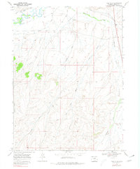
1969 Map of Pole Gulch
USGS Topo · Published 1980About this map
The Little Snake River winds through the northern reaches of this Colorado landscape, defining a corridor of early water engineering in Moffat County. The map documents an intricate network of irrigation infrastructure designed to harness the river, including the Gibson DITCH, Blair DITCH, and Trowel DITCH, alongside the West Side Canal. These features reflect the vital importance of water rights and land management in the high plains. South of the river, the terrain rises into a series of drainages such as Gledhill Draw and the extensive Pole Gulch system. Industrial markers of the late 1960s are evident in the form of scattered Oil Wells, a Gravel Pit, and various drill holes, indicating the area's transition toward resource extraction while maintaining its fundamental ranching and agricultural character.
Find a feature on this map
16 named features on this map. Tap any name to fly to it.
Don’t see what you’re looking for? This feature index may not catch every label — zoom into the map to look around manually.
Map Details
Editions of this 1969 Pole Gulch Map
3 editions found
Other maps of this area

1916 · Craig
USGS Topo · 1:125,000

1954 · Rawlins
USGS Topo · 1:250,000

1954 · Craig
USGS Topo · 1:250,000

1957 · Craig
USGS Topo · 1:250,000

1957 · Baggs
USGS Topo · 1:62,500

1958 · Rawlins
USGS Topo · 1:250,000

1958 · Craig
USGS Topo · 1:250,000

1960 · Craig
USGS Topo · 1:250,000

1962 · Rawlins
USGS Topo · 1:250,000

1962 · Craig
USGS Topo · 1:250,000