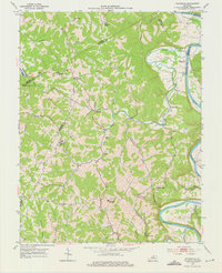
1953 Map of Polsgrove
USGS Topo · Published 1976About this map
Harpers Ferry and the winding course of the Kentucky River dominate this early 1950s survey of the borderlands between Franklin, Henry, and Owen Counties. The landscape is defined by the sharp meanders of Flat Creek and Sand Ripple Creek, which carve through the terrain to meet the river at Lecompte Bottom. This era shows a distributed network of upland rural communities and valley floor settlements connected by winding ridge roads. Genealogists will find significant detail in the numerous family landmarks and rural institutions, including the Bald Knob High Sch and several country churches like Pleasant Ridge Ch and Mt Carmel Ch. The presence of small burial grounds such as Hutcherson Cem and Moore Cem near the Polsgrove and Ottusville areas provides specific touchpoints for local family history research in this river-oriented region.
Find a feature on this map
40 named features on this map. Tap any name to fly to it.
Don’t see what you’re looking for? This feature index may not catch every label — zoom into the map to look around manually.
Map Details
Editions of this 1953 Polsgrove Map
4 editions found

Other maps of this area

1906 · Lockport
USGS Topo · 1:48,000

1908 · Lockport
USGS Topo · 1:62,500

1922 · Frankfort
USGS Topo · 1:48,000

1923 · Waddy
USGS Topo · 1:48,000

1924 · Frankfort
USGS Topo · 1:62,500

1925 · Mount Eden
USGS Topo · 1:48,000

1927 · Mount Eden
USGS Topo · 1:62,500

1928 · New Castle
USGS Topo · 1:48,000

1932 · New Castle
USGS Topo · 1:62,500

1953 · Monterey
USGS Topo · 1:24,000