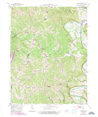
1953 Map of Polsgrove
USGS Topo · Published 1987About this map
The Kentucky River carves deep, winding bends through the countryside where Franklin, Owen, and Henry counties meet. This mid-century view shows a landscape defined by sharp ridges and narrow creek bottoms, where rural life centered on dispersed communities like Polsgrove and Harvieland. The river's influence is evident in the naming of large meanders such as Steamboat Hollow Bend and Payton Bend, while the interior terrain is marked by family-named landmarks like Lecomte Bottom and the Hutcherson Cem.
Find a feature on this map
40 named features on this map. Tap any name to fly to it.
Don’t see what you’re looking for? This feature index may not catch every label — zoom into the map to look around manually.
Map Details
Editions of this 1953 Polsgrove Map
4 editions found

Other maps of this area

1906 · Lockport
USGS Topo · 1:48,000

1908 · Lockport
USGS Topo · 1:62,500

1922 · Frankfort
USGS Topo · 1:48,000

1923 · Waddy
USGS Topo · 1:48,000

1924 · Frankfort
USGS Topo · 1:62,500

1925 · Mount Eden
USGS Topo · 1:48,000

1927 · Mount Eden
USGS Topo · 1:62,500

1928 · New Castle
USGS Topo · 1:48,000

1932 · New Castle
USGS Topo · 1:62,500

1953 · Monterey
USGS Topo · 1:24,000