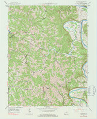
1953 Map of Polsgrove
USGS Topo · Published 1984About this map
Harpers Ferry and the winding Kentucky River anchor this mid-century portrait of northern Franklin County. The landscape is defined by the sharp meanders of the river and a dense network of tributaries including Flat Creek, Sixmile Creek, and Stony Creek. The region’s rural social infrastructure is well-preserved here, showing several scattered community centers such as Harvieland, Ottusville, and Polsgrove.
Find a feature on this map
39 named features on this map. Tap any name to fly to it.
Don’t see what you’re looking for? This feature index may not catch every label — zoom into the map to look around manually.
Map Details
Editions of this 1953 Polsgrove Map
4 editions found

Other maps of this area

1906 · Lockport
USGS Topo · 1:48,000

1908 · Lockport
USGS Topo · 1:62,500

1922 · Frankfort
USGS Topo · 1:48,000

1923 · Waddy
USGS Topo · 1:48,000

1924 · Frankfort
USGS Topo · 1:62,500

1925 · Mount Eden
USGS Topo · 1:48,000

1927 · Mount Eden
USGS Topo · 1:62,500

1928 · New Castle
USGS Topo · 1:48,000

1932 · New Castle
USGS Topo · 1:62,500

1953 · Monterey
USGS Topo · 1:24,000