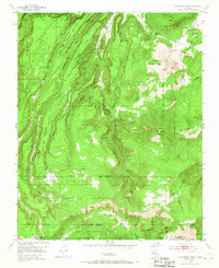
1953 Map of Polvadera Peak
USGS Topo · Published 1967About this map
The Polvadera Grant and Juan Jose Lobato Grant overlap a high-altitude landscape of mesas and deep drainage basins in the early 1950s. At the heart of this survey is the Polvadera Sawmill Camp, reflecting the region's timber activity at the edge of the Santa Fe National Forest. The terrain is defined by dramatic elevations, from the heights of Polvadera Peak and Chicoma Mountain to the branching waters of Polvadera Creek and Santa Clara Creek. High-mountain meadows or marshlands, such as Cienega Redonda and Cienega del Oso, are scattered across the timbered ridges, while a Pack Trail provides the primary passage through the Baca Location No 1 and the surrounding rugged forest land.
Find a feature on this map
38 named features on this map. Tap any name to fly to it.
Don’t see what you’re looking for? This feature index may not catch every label — zoom into the map to look around manually.
Map Details
Editions of this 1953 Polvadera Peak Map
3 editions found

Other maps of this area

1890 · Jemes
USGS Topo · 1:125,000

1892 · Jemes
USGS Topo · 1:125,000

1892 · Santa Clara
USGS Topo · 1:125,000

1909 · Gallina
USGS Topo · 1:125,000

1918 · Abiquiu
USGS Topo · 1:125,000

1937 · Jemez Springs
USGS Topo · 1:48,000

1944 · Jemez Springs
USGS Topo · 1:62,500

1952 · Valle Toledo
USGS Topo · 1:24,000

1952 · Jemez Springs
USGS Topo · 1:62,500

1952 · Guaje Mountain
USGS Topo · 1:24,000