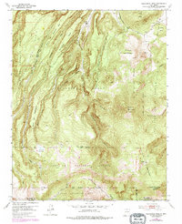
1953 Map of Polvadera Peak
USGS Topo · Published 1978About this map
Polvadera Sawmill Camp stands as a focal point of activity in this high-altitude landscape within the Santa Fe National Forest. This 1953 survey, updated with 1970s woodland data, reveals a complex web of land ownership defined by historical land grants. Boundaries for the Polvadera Grant, the Juan Jose Lobato Grant, and the Town of Abiquiu Grant converge across these peaks, illustrating how Spanish and Mexican era land divisions continued to shape the modern geography of Rio Arriba and Sandoval counties. The terrain is defined by dramatic elevations, from the heights of Polvadera Peak and Chicoma Mountain to the high meadows of Cienega Redonda and Cienega del Oso. Transportation is limited to the Polvadera Road and an extensive Pack Trail system, which connects remote points like La Tetilla and Cerro Pelon through drainage systems like Cañoncito Seco and Abiquiu Creek.
Find a feature on this map
46 named features on this map. Tap any name to fly to it.
Don’t see what you’re looking for? This feature index may not catch every label — zoom into the map to look around manually.
Map Details
Editions of this 1953 Polvadera Peak Map
3 editions found

Other maps of this area

1890 · Jemes
USGS Topo · 1:125,000

1892 · Jemes
USGS Topo · 1:125,000

1892 · Santa Clara
USGS Topo · 1:125,000

1909 · Gallina
USGS Topo · 1:125,000

1918 · Abiquiu
USGS Topo · 1:125,000

1937 · Jemez Springs
USGS Topo · 1:48,000

1944 · Jemez Springs
USGS Topo · 1:62,500

1952 · Valle Toledo
USGS Topo · 1:24,000

1952 · Jemez Springs
USGS Topo · 1:62,500

1952 · Guaje Mountain
USGS Topo · 1:24,000