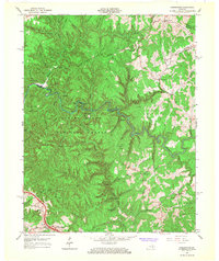
1966 Map of Pomeroyton
USGS Topo · Published 1968About this map
Red River carves a deep path through the heart of the Daniel Boone National Forest, defining a landscape of high ridges and narrow creek bottoms. The terrain is marked by an exceptional concentration of geological features, including the massive Osborne Bend and natural formations like Sky Bridge, Princess Arch, and Cloud Splitter. Human settlement is sparse and concentrated on the higher ground of Pine Mountain Ridge and near the valley floors, where small communities like Pomeroyton and Valeria established themselves. The map documents essential local institutions such as the Dessie Scott Childrens Home and Calaboose Sch, alongside religious sites like Daniel Ch. While much of the area remained protected forest, the presence of an Oil Well near the northern boundary and the Pine Ridge Interchange at the southwestern corner indicates the modern infrastructure beginning to reach into these Kentucky highlands during the mid-1960s.
Find a feature on this map
78 named features on this map. Tap any name to fly to it.
Don’t see what you’re looking for? This feature index may not catch every label — zoom into the map to look around manually.
Map Details
Editions of this 1966 Pomeroyton Map
4 editions found
Other maps of this area

1889 · Salyersville
USGS Topo · 1:125,000

1891 · Salyersville
USGS Topo · 1:125,000

1892 · Beattyville
USGS Topo · 1:125,000

1899 · Salyersville
USGS Topo · 1:125,000

1951 · Landsaw
USGS Topo · 1:24,000

1951 · Ezel
USGS Topo · 1:24,000

1951 · Hazel Green
USGS Topo · 1:24,000

1951 · Pomeroyton
USGS Topo · 1:24,000

1952 · Scranton
USGS Topo · 1:24,000

1952 · Frenchburg
USGS Topo · 1:24,000