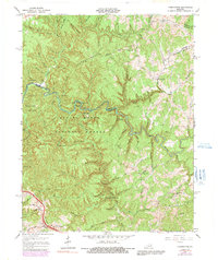
1966 Map of Pomeroyton
USGS Topo · Published 1991About this map
The Middle Fork Red River carves a deep path through this portion of the Daniel Boone National Forest at the convergence of Wolfe, Menifee, and Morgan counties. The landscape is defined by its complex geological formations, featuring a high concentration of natural sandstone spans such as Sky Bridge, Princess Arch, and Angel Windows. While much of the terrain is dominated by ridges like Corner Ridge and Koomer Ridge, the map also documents the mid-century infrastructure of the rural Kentucky foothills. Small communities like Pomeroyton and Valeria are connected by winding state routes, while institutional landmarks like the Dessie Scott Childrens Home near Pine Ridge reflect the area's local history. Local spiritual and educational centers, including Pine Branch Ch and Catahooche Sch, are tucked into the valleys along Swift Camp Creek and Blackwater Creek, providing a detailed view of the region's social geography before late-20th-century shifts.
Find a feature on this map
86 named features on this map. Tap any name to fly to it.
Don’t see what you’re looking for? This feature index may not catch every label — zoom into the map to look around manually.
Map Details
Editions of this 1966 Pomeroyton Map
4 editions found
Other maps of this area

1889 · Salyersville
USGS Topo · 1:125,000

1891 · Salyersville
USGS Topo · 1:125,000

1892 · Beattyville
USGS Topo · 1:125,000

1899 · Salyersville
USGS Topo · 1:125,000

1951 · Landsaw
USGS Topo · 1:24,000

1951 · Ezel
USGS Topo · 1:24,000

1951 · Hazel Green
USGS Topo · 1:24,000

1951 · Pomeroyton
USGS Topo · 1:24,000

1952 · Scranton
USGS Topo · 1:24,000

1952 · Frenchburg
USGS Topo · 1:24,000