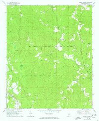
1969 Map of Poplar Springs
USGS Topo · Published 1973About this map
The William B Bankhead National Forest covers much of this North Alabama landscape, defined by a dense network of tributaries feeding into the larger Clear Creek and Blackwater Creek. In the late 1960s, small settlements and rural crossroads like Poplar Springs and Ashbank remained focal points for local life, connected by winding roads through the timberland. The map reveals a high density of country churches and community gathering places, including New Hope Ch, Rocky Plain Ch, and Mt Ebron Ch. Genealogists may find interest in markers like Blue Springs Cem or the Spain Ford crossing, while the presence of an Oil Well and the Southern railroad line in the southwest corner near Hopewell Ch points to the area's mixed economy of natural resource extraction and transportation.
Find a feature on this map
38 named features on this map. Tap any name to fly to it.
Don’t see what you’re looking for? This feature index may not catch every label — zoom into the map to look around manually.
Map Details
Editions of this 1969 Poplar Springs Map
2 editions found
Other maps of this area

1893 · Jasper
USGS Topo · 1:125,000

1936 · Delmar
USGS Topo · 1:24,000

1949 · Manchester
USGS Topo · 1:24,000

1949 · Nauvoo
USGS Topo · 1:24,000

1950 · Nauvoo
USGS Topo · 1:24,000

1950 · Manchester
USGS Topo · 1:24,000

1953 · Birmingham
USGS Topo · 1:250,000

1956 · Birmingham
USGS Topo · 1:250,000

1956 · Gadsden
USGS Topo · 1:250,000

1957 · Birmingham
USGS Topo · 1:250,000