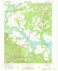
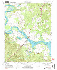
1968 Map of Port Royal
USGS Topo · Published 1971About this map
Port Royal and Port Conway face one another across the Rappahannock River, linked by the James Madison Memorial Bridge in this late-1960s survey. The landscape is defined by the sharp bends of the river, where features like Thorofare and Cleve Marsh show the complex hydrology of the Virginia tidewater. To the south, the terrain shifts into the controlled grounds of the Camp Hill Military Reservation, a significant land use that borders agricultural and rural residential zones marked by small crossroads like Port Royal Cross Roads and Cash Corner. Local history and genealogy are anchored by scattered landmarks such as Emmanuel Ch, Salem Ch, and the Taliaferro Landing Strip. The presence of numerous Gravel Pits and named water bodies like Gouldman Pond and Millers Pond indicates an economy tied to both resource extraction and the river's natural drainage patterns.
Find a feature on this map
51 named features on this map. Tap any name to fly to it.
Don’t see what you’re looking for? This feature index may not catch every label — zoom into the map to look around manually.
Map Details
Editions of this 1968 Port Royal Map
5 editions found
Other maps of this area

1889 · Fredericksburg
USGS Topo · 1:125,000

1892 · Fredericksburg
USGS Topo · 1:125,000

1894 · Fredericksburg
USGS Topo · 1:125,000

1926 · Stafford
USGS Topo · 1:62,500

1931 · Stafford
USGS Topo · 1:62,500

1942 · Bowling Green
USGS Topo · 1:31,680

1942 · Upper Zion
USGS Topo · 1:31,680

1942 · Occupacia
USGS Topo · 1:31,680

1942 · Rollins Fork
USGS Topo · 1:31,680

1942 · Port Royal
USGS Topo · 1:31,680