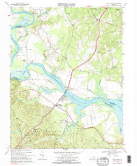
1968 Map of Port Royal
USGS Topo · Published 1985About this map
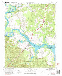
Port Royal and Port Conway face one another across the Rappahannock River, connected by the James Madison Memorial Bridge during this late 1960s survey. This segment of the river is characterized by dramatic meanders and marshy stretches like Cleve Marsh and White Marsh, where the boundary between Caroline and King George counties follows the shifting current. To the south, the landscape transitions into the specialized infrastructure of the A P Hill Military Reservation, featuring the Taliaferro Landing Strip and tactical landmarks like Camp Custer. Small settlements such as Rollins Fork, Dogue, and Office Hall anchor the surrounding rural highlands, while historical river access points like Hop Yard Landing reflect the area's long-standing reliance on the waterway for transport and commerce.
Find a feature on this map
54 named features on this map. Tap any name to fly to it.
Don’t see what you’re looking for? This feature index may not catch every label — zoom into the map to look around manually.
Map Details
Editions of this 1968 Port Royal Map
5 editions found
Other maps of this area

1889 · Fredericksburg
USGS Topo · 1:125,000

1892 · Fredericksburg
USGS Topo · 1:125,000

1894 · Fredericksburg
USGS Topo · 1:125,000

1926 · Stafford
USGS Topo · 1:62,500

1931 · Stafford
USGS Topo · 1:62,500

1942 · Bowling Green
USGS Topo · 1:31,680

1942 · Upper Zion
USGS Topo · 1:31,680

1942 · Occupacia
USGS Topo · 1:31,680

1942 · Rollins Fork
USGS Topo · 1:31,680

1942 · Port Royal
USGS Topo · 1:31,680