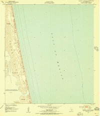
1952 Map of Potrero Lopeno SE
USGS Topo · Published 1956About this map
Padre Island forms a narrow, dynamic barrier between the Gulf of Mexico and the shallow expanse of the Laguna Madre in this mid-century coastal study. The landscape is defined by vast stretches of Sand and Mud and Shifting Sand Dunes that reached heights of 26 feet during the early 1950s. This specific stretch of the Texas coastline is notably sparse, highlighting the isolation of the island before significant modern development. Sparse traces of human activity are recorded by labels for Ruins and a station marked Meteor, suggesting historical navigational or scientific presence in a region primarily shaped by wind and tide. The map captures the shoreline as it existed following 1948 aerial photography and 1949 ground surveys, documenting the ephemeral nature of the dunes and the shifting interface of the South Texas coast.
Find a feature on this map
8 named features on this map. Tap any name to fly to it.
Don’t see what you’re looking for? This feature index may not catch every label — zoom into the map to look around manually.
Map Details
Editions of this 1952 Potrero Lopeno SE Map
3 editions found
Other maps of this area

1923 · Lopena Island
USGS Topo · 1:62,500

1951 · South of Potrero Lopeno NE
USGS Topo · 1:24,000

1951 · Potrero Lopeno NW
USGS Topo · 1:24,000

1952 · Potrero Lopeno SE
USGS Topo · 1:24,000

1952 · South of Potrero Lopeno NW
USGS Topo · 1:24,000

1952 · Potrero Lopeno SW
USGS Topo · 1:24,000

1952 · Potrero Lopeno
USGS Topo · 1:62,500

1952 · South of Potrero Lopeno
USGS Topo · 1:62,500

1953 · Brownsville
USGS Topo · 1:250,000

1956 · Brownsville
USGS Topo · 1:250,000