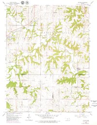
1960 Map of Potter
USGS Topo · Published 1979About this map
The settlement of Potter and its surrounding countryside are captured during a period of transition in the mid-20th century, where the rural landscape of northeast Kansas was defined by small townships and traditional agriculture. The terrain of Mount Pleasant is marked by a network of drainage ways including Stranger Creek and Mooney Creek, which carved paths through the rolling hills. Genealogists and local historians will find significant data points in the numerous rural institutions, such as School No 74, Hawthorne Sch, and Corpus Christi Sch.
Find a feature on this map
33 named features on this map. Tap any name to fly to it.
Don’t see what you’re looking for? This feature index may not catch every label — zoom into the map to look around manually.
Map Details
Editions of this 1960 Potter Map
4 editions found
Other maps of this area

1885 · Atchison
USGS Topo · 1:125,000

1886 · Oskaloosa
USGS Topo · 1:125,000

1888 · Oskaloosa
USGS Topo · 1:125,000

1888 · Atchison
USGS Topo · 1:125,000

1893 · Atchison
USGS Topo · 1:125,000

1894 · Oskaloosa
USGS Topo · 1:125,000

1926 · Atchison
USGS Topo · 1:62,500

1948 · Oak Mills
USGS Topo · 1:24,000

1950 · Kansas City
USGS Topo · 1:250,000

1950 · Easton
USGS Topo · 1:24,000