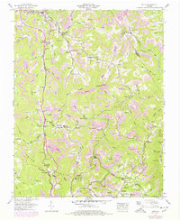
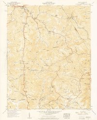
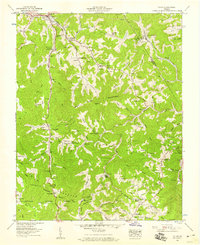
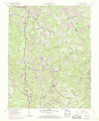
1957 Map of Pound
USGS Topo · Published 1978About this map
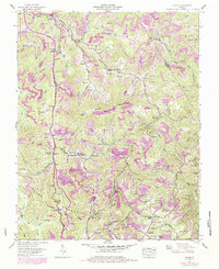
Pound sits at the confluence of the Pound River and several of its forks, serving as a gateway through the Appalachian terrain of Wise County. This landscape is defined by the steep ridges of Indian Ridge and Bold Camp Mountain, where the Tennessee Mountain Valley Divide snakes through the southern portion of the sheet. The settlement patterns follow the winding creek beds, as evidenced by the dense concentration of family cemeteries and small rural schools like Dotson Sch and Skeen Sch. Extensive Strip mines dot the hillsides of the Dickenson Co and Wise Co border, illustrating the intensive coal extraction industry that shaped the local economy. Religious life is well-documented through numerous small sanctuaries, including Firbie Chapel and the Old Regular Ch near Bean Gap, reflecting the area's deep-rooted community foundations.
Find a feature on this map
127 named features on this map. Tap any name to fly to it.
Don’t see what you’re looking for? This feature index may not catch every label — zoom into the map to look around manually.
Map Details
Editions of this 1957 Pound Map
5 editions found
Other maps of this area

1886 · Grundy
USGS Topo · 1:125,000

1890 · Whitesburg
USGS Topo · 1:125,000

1890 · Grundy
USGS Topo · 1:125,000

1892 · Grundy
USGS Topo · 1:125,000

1892 · Whitesburg
USGS Topo · 1:125,000

1894 · Estillville
USGS Topo · 1:125,000

1897 · Bristol
USGS Topo · 1:125,000

1902 · Bristol
USGS Topo · 1:125,000

1912 · Pound
USGS Topo · 1:48,000

1913 · Clintwood
USGS Topo · 1:62,500