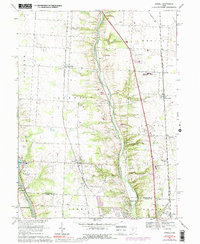
1967 Map of Powell
USGS Topo · Published 1992About this map
The Olentangy River carves a deep central valley through this Delaware County landscape, serving as the primary geographic anchor for established settlements like Powell and Lewis Center. During this era of the late 1960s, the region maintains a distinct rail-oriented character, with the Chesapeake and Ohio, Norfolk and Western, and Penn Central lines all traversing the terrain. These rail corridors link smaller hamlets and rural hubs such as Hyatts, Orange, and Gregory.
Find a feature on this map
46 named features on this map. Tap any name to fly to it.
Don’t see what you’re looking for? This feature index may not catch every label — zoom into the map to look around manually.
Map Details
Editions of this 1967 Powell Map
4 editions found
Other maps of this area

1901 · Dublin
USGS Topo · 1:62,500

1902 · Westerville
USGS Topo · 1:62,500

1903 · Dublin
USGS Topo · 1:62,500

1904 · Westerville
USGS Topo · 1:62,500

1915 · Marengo
USGS Topo · 1:62,500

1924 · Delaware
USGS Topo · 1:62,500

1925 · Delaware
USGS Topo · 1:62,500

1943 · Marengo
USGS Topo · 1:62,500

1944 · Delaware
USGS Topo · 1:62,500

1950 · Marion
USGS Topo · 1:250,000