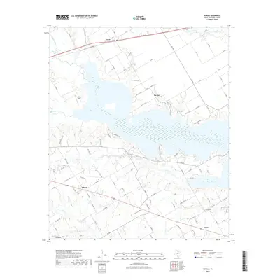
2019 Map of Powell
USGS Topo · Published 2019About this map
Lake Corsicana dominates the central portion of this Navarro County landscape, its irregular shoreline creating a complex geography of inlets and peninsulas. The 2019 survey documents a region where agricultural roots and rural settlements persist alongside the modern influence of the reservoir. To the north, the community of Powell is situated near the confluence of Chambers Creek and Briar Cr, while Mildred and Eureka anchor the southern reaches. This map is particularly valuable for genealogical research, clearly identifying several burial grounds including Providence Cem, Elm Flat Cem, and Woods Cem. The transition from historic land use to more contemporary developments is visible in the network of county roads and the presence of the JTJ Ranch Airport, reflecting the area's continued evolution from its early cattle and farming foundations.
Find a feature on this map
107 named features on this map. Tap any name to fly to it.
Don’t see what you’re looking for? This feature index may not catch every label — zoom into the map to look around manually.
Map Details
Editions of this 2019 Powell Map
This is the sole edition of this map. No revisions or reprints were ever made.
Other maps of this area

1954 · Dallas
USGS Topo · 1:250,000

1954 · Waco
USGS Topo · 1:250,000

1955 · Waco
USGS Topo · 1:250,000

1958 · Dallas
USGS Topo · 1:250,000

1959 · Powell
USGS Topo · 1:24,000

1960 · Winkler
USGS Topo · 1:24,000

1960 · Streetman
USGS Topo · 1:24,000

1960 · Goodlow Park
USGS Topo · 1:24,000

1961 · Kerens
USGS Topo · 1:24,000

1961 · Chatfield
USGS Topo · 1:24,000