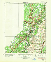
1935 Map of Powhatan
USGS Topo · Published 1949About this map
Black River and the Spring River converge in this mid-1930s landscape, creating a complex network of meanders, oxbows, and riverfront landmarks. The terrain is defined by its water, featuring dozens of named lakes and bays such as Portia Bay, Horseshoe Lake, and Ball Pizzle Lake. These waterways served as the primary arteries for local transport and commerce, evidenced by river crossings like Gibson Ferry and Sissons Ld.
Find a feature on this map
66 named features on this map. Tap any name to fly to it.
Don’t see what you’re looking for? This feature index may not catch every label — zoom into the map to look around manually.
Map Details
Editions of this 1935 Powhatan Map
4 editions found
Other maps of this area

1932 · Strawberry
USGS Topo · 1:62,500

1932 · Walnut Ridge
USGS Topo · 1:62,500

1934 · Powhatan
USGS Topo · 1:62,500

1935 · Powhatan
USGS Topo · 1:62,500

1935 · Sedgwick
USGS Topo · 1:62,500

1935 · Alicia
USGS Topo · 1:62,500

1935 · Strawberry
USGS Topo · 1:62,500

1935 · Reyno
USGS Topo · 1:62,500

1935 · Walnut Ridge
USGS Topo · 1:62,500

1941 · Strawberry
USGS Topo · 1:62,500