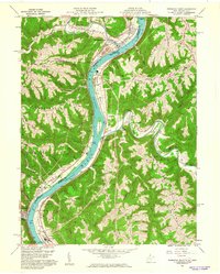
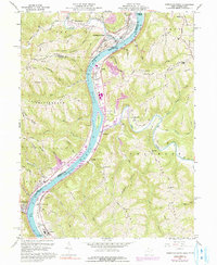
1960 Map of Powhatan Point
USGS Topo · Published 1961About this map
The Ohio River corridor at the turn of the 1960s reveals a landscape defined by heavy industry and river navigation along the border of Ohio and West Virginia. Industrial centers like Natrium and Cresap are marked by substations and pumping stations, while the river itself is regulated by Lock No. 14 and frequented by the Pennsylvania and Baltimore and Ohio railroads. The map captures the significant industrial footprint along the Cresap Bottom, including elevators and chemical-related infrastructure near the riverbanks.
Find a feature on this map
66 named features on this map. Tap any name to fly to it.
Don’t see what you’re looking for? This feature index may not catch every label — zoom into the map to look around manually.
Map Details
Editions of this 1960 Powhatan Point Map
5 editions found
Other maps of this area

1903 · Littleton
USGS Topo · 1:62,500

1904 · Cameron
USGS Topo · 1:62,500

1905 · Littleton
USGS Topo · 1:62,500

1905 · Clarington
USGS Topo · 1:62,500

1906 · New Martinsville
USGS Topo · 1:62,500

1924 · New Martinsville
USGS Topo · 1:62,500

1924 · Littleton
USGS Topo · 1:62,500

1926 · Littleton
USGS Topo · 1:62,500

1926 · New Martinsville
USGS Topo · 1:62,500

1935 · Cameron
USGS Topo · 1:62,500