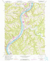
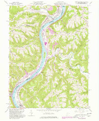
1960 Map of Powhatan Point
USGS Topo · Published 1991About this map
The Ohio River corridor at the intersection of West Virginia and Ohio reveals a dense landscape of industrial development and rural ridges during the mid-20th century. Large-scale infrastructure like the Baltimore and Ohio and Conrail rail lines hug the riverbanks, serving the heavy industries found at Natrium and Cresap. Along the western shore, Powhatan Point stands as a primary population center, while across the water in West Virginia, small riverside settlements like Woodlands and Franklin occupy the narrow floodplain beneath Burch Ridge.
Find a feature on this map
72 named features on this map. Tap any name to fly to it.
Don’t see what you’re looking for? This feature index may not catch every label — zoom into the map to look around manually.
Map Details
Editions of this 1960 Powhatan Point Map
5 editions found
Other maps of this area

1903 · Littleton
USGS Topo · 1:62,500

1904 · Cameron
USGS Topo · 1:62,500

1905 · Littleton
USGS Topo · 1:62,500

1905 · Clarington
USGS Topo · 1:62,500

1906 · New Martinsville
USGS Topo · 1:62,500

1924 · New Martinsville
USGS Topo · 1:62,500

1924 · Littleton
USGS Topo · 1:62,500

1926 · Littleton
USGS Topo · 1:62,500

1926 · New Martinsville
USGS Topo · 1:62,500

1935 · Cameron
USGS Topo · 1:62,500