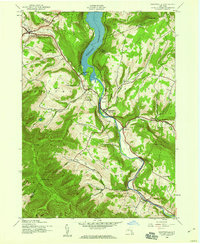
1945 Map of Prattsville
USGS Topo · Published 1960About this map
Schoharie Reservoir dominates the northern valley where Greene and Delaware counties meet, a major water feature fed by the winding Schoharie Creek. The mid-1940s landscape is defined by its steep Catskill topography, featuring notable summits like Bearpen Mtn and Bald Mtn. The village of Prattsville serves as a central hub, flanked by the distinctive Pratt Rocks to the east. The map preserves the rural infrastructure of the era, marking local education sites like School No 1 and Little West Kill Sch. Genealogists will find several family-named burial grounds, including the Huntersfield Cem, Deyo Cem, and Rappleyea Cem. To the west, Grand Gorge sits at a critical mountain pass, while the southern reaches of the map extend into the protected lands of Catskill State Park.
Find a feature on this map
46 named features on this map. Tap any name to fly to it.
Don’t see what you’re looking for? This feature index may not catch every label — zoom into the map to look around manually.
Map Details
Editions of this 1945 Prattsville Map
3 editions found
Other maps of this area

1900 · Phoenicia
USGS Topo · 1:62,500

1901 · Margaretville
USGS Topo · 1:62,500

1901 · Gilboa
USGS Topo · 1:62,500

1903 · Gilboa
USGS Topo · 1:62,500

1903 · Phoenicia
USGS Topo · 1:62,500

1904 · Hobart
USGS Topo · 1:62,500

1904 · Margaretville
USGS Topo · 1:62,500

1945 · West Kill
USGS Topo · 1:24,000

1945 · Gilboa
USGS Topo · 1:24,000

1945 · Fleischmanns
USGS Topo · 1:24,000