
1955 Map of Primrose
USGS Topo · Published 1956About this map
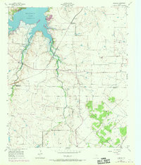
Benbrook Lake dominates the northern landscape of this mid-1950s survey, marking a period of significant water management and infrastructure development south of Fort Worth. The terrain is defined by the drainage basins of Mustang Creek, Rocky Creek, and Shannon Creek, which flow through a landscape of working ranches and rural industrial sites. Evidence of changing transportation networks is visible in the presence of the Gulf Colorado and Santa Fe railroad line contrasted with a nearby Old Railroad Grade, showing how the iron horse routes were already being consolidated or realigned. Small settlements like Primrose and Plover serve as local hubs, while numerous scattered Windmills across the Tarrant and Johnson County line indicate the ongoing reliance on groundwater for livestock. The map also documents resource extraction through several Gravel Pits and a small Cem that provides a point of interest for genealogical research.
Find a feature on this map
17 named features on this map. Tap any name to fly to it.
Don’t see what you’re looking for? This feature index may not catch every label — zoom into the map to look around manually.
Map Details
Editions of this 1955 Primrose Map
2 editions found
Other maps of this area

1889 · Granbury
USGS Topo · 1:125,000

1891 · Weatherford
USGS Topo · 1:125,000

1891 · Cleburne
USGS Topo · 1:125,000

1893 · Weatherford
USGS Topo · 1:125,000

1894 · Cleburne
USGS Topo · 1:125,000

1894 · Fort Worth
USGS Topo · 1:125,000

1928 · Godley
USGS Topo · 1:62,500

1954 · Dallas
USGS Topo · 1:250,000

1955 · Burleson
USGS Topo · 1:24,000

1955 · Aledo
USGS Topo · 1:24,000