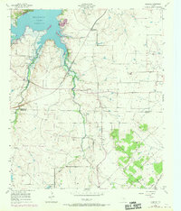
1955 Map of Primrose
USGS Topo · Published 1969About this map
Benbrook Lake dominates the northwest corner of this North Texas landscape, where the reservoir's Spillway and controlled inundation zones meet the rolling prairie. The map documents the rural character of the Tarrant and Johnson County line during the mid-1950s, later updated with late-1960s revisions. This period was defined by a transition from traditional ranching and rail-oriented hamlets like Primrose and Plover toward a more modern infrastructure.
Find a feature on this map
15 named features on this map. Tap any name to fly to it.
Don’t see what you’re looking for? This feature index may not catch every label — zoom into the map to look around manually.
Map Details
Editions of this 1955 Primrose Map
2 editions found

Other maps of this area

1889 · Granbury
USGS Topo · 1:125,000

1891 · Weatherford
USGS Topo · 1:125,000

1891 · Cleburne
USGS Topo · 1:125,000

1893 · Weatherford
USGS Topo · 1:125,000

1894 · Cleburne
USGS Topo · 1:125,000

1894 · Fort Worth
USGS Topo · 1:125,000

1928 · Godley
USGS Topo · 1:62,500

1954 · Dallas
USGS Topo · 1:250,000

1955 · Burleson
USGS Topo · 1:24,000

1955 · Aledo
USGS Topo · 1:24,000