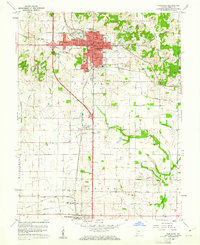
1959 Map of Princeton
USGS Topo · Published 1961About this map
Princeton serves as the focal point of this Gibson County survey, showing a well-established community anchored by the central Courthouse and the Southern and Chicago And Eastern Illinois railroads. The town's social fabric is visible through several educational and religious landmarks, including Lowell Sch, Franklin Sch, and St Josephs Ch. To the south and east, the landscape transitions into a mix of industrial and recreational sites, such as the Oil Refinery and a Drive-in Theater, while Baldwin Heights marks a residential expansion of the city limits.
Find a feature on this map
43 named features on this map. Tap any name to fly to it.
Don’t see what you’re looking for? This feature index may not catch every label — zoom into the map to look around manually.
Map Details
Editions of this 1959 Princeton Map
4 editions found
Other maps of this area

1901 · Princeton
USGS Topo · 1:62,500

1901 · Haubstadt
USGS Topo · 1:62,500

1902 · Ditney
USGS Topo · 1:125,000

1902 · Boonville
USGS Topo · 1:62,500

1903 · Haubstadt
USGS Topo · 1:62,500

1903 · Petersburg
USGS Topo · 1:62,500

1903 · Princeton
USGS Topo · 1:62,500

1903 · Patoka
USGS Topo · 1:125,000

1956 · Vincennes
USGS Topo · 1:250,000

1957 · Vincennes
USGS Topo · 1:250,000