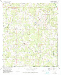
1972 Map of Progress
USGS Topo · Published 1990About this map
The Bogue Chitto river system and its southern tributaries define the rural landscape of southern Mississippi and northern Louisiana in the early 1970s. This survey centers on Progress, a crossroad settlement situated between the watersheds of Silver Creek and McNab Creek. The map provides a detailed view of the community's social infrastructure, including the Yale Community Center and several dispersed churches such as Bala Chitto Ch and Rose Hill Ch.
Find a feature on this map
42 named features on this map. Tap any name to fly to it.
Don’t see what you’re looking for? This feature index may not catch every label — zoom into the map to look around manually.
Map Details
Editions of this 1972 Progress Map
2 editions found
Other maps of this area

1939 · Sunny Hill
USGS Topo · 1:31,680

1939 · Clifton
USGS Topo · 1:31,680

1940 · Spring Creek
USGS Topo · 1:31,680

1953 · Natchez
USGS Topo · 1:250,000

1954 · Baton Rouge
USGS Topo · 1:250,000

1956 · Natchez
USGS Topo · 1:250,000

1956 · Baton Rouge
USGS Topo · 1:250,000
1958 · Mount Hermon
USGS Topo · 1:62,500
1958 · Franklinton
USGS Topo · 1:62,500

1959 · Natchez
USGS Topo · 1:250,000