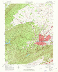
1965 Map of Pulaski
USGS Topo · Published 1971About this map
Pulaski serves as the industrial and civic anchor of this 1960s study, situated where the Norfolk and Western railway corridor meets the foothills of Draper Mountain. The map illustrates a developed town infrastructure, including Calfee Park, several schools like Northwood Sch, and the county Courthouse. Beyond the urban center, the landscape is defined by the steep ridgelines of the Jefferson National Forest and Walker Mountain, where narrow hollows like Bateman Hollow and Pondlick Branch cut through the terrain. Evidence of local industry and infrastructure is present in the Empire Mine to the north and the Gatewood Reservoir to the west. This survey captures the transition from the town's dense residential grid to the rural surrounding areas of Draper and Stabtown, marked by numerous country churches such as Jordans Chapel and Clarks Chapel.
Find a feature on this map
68 named features on this map. Tap any name to fly to it.
Don’t see what you’re looking for? This feature index may not catch every label — zoom into the map to look around manually.
Map Details
Editions of this 1965 Pulaski Map
4 editions found
Other maps of this area

1889 · Hillsville
USGS Topo · 1:125,000

1890 · Dublin
USGS Topo · 1:125,000

1891 · Dublin
USGS Topo · 1:125,000

1892 · Hillsville
USGS Topo · 1:125,000

1896 · Hillsville
USGS Topo · 1:125,000

1930 · Max Meadows
USGS Topo · 1:62,500

1934 · Pulaski
USGS Topo · 1:48,000

1940 · Pulaski
USGS Topo · 1:62,500

1950 · Radford
USGS Topo · 1:62,500

1953 · Winston-Salem
USGS Topo · 1:250,000