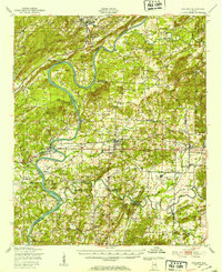
1947 Map of Ragland
USGS Topo · Published 1953About this map
The Coosa River defines the western landscape of this mid-century survey, winding past Emory Bend and the Broken Arrow Shoals. The area is a dense network of rural communities and small industries, centered around Lincoln and Riverside. In the east, the sprawling Fort McClellan Military Reservation and the inactive Anniston Air Force Base reflect the significant military presence in Alabama during the post-war years.
Find a feature on this map
61 named features on this map. Tap any name to fly to it.
Don’t see what you’re looking for? This feature index may not catch every label — zoom into the map to look around manually.
Map Details
Editions of this 1947 Ragland Map
3 editions found

Other maps of this area

1889 · Springville
USGS Topo · 1:125,000

1890 · Talladega
USGS Topo · 1:125,000

1891 · Ashland
USGS Topo · 1:125,000

1892 · Springville
USGS Topo · 1:125,000

1892 · Talladega
USGS Topo · 1:125,000

1900 · Anniston
USGS Topo · 1:125,000

1943 · Talladega
USGS Topo · 1:62,500

1946 · Talladega
USGS Topo · 1:62,500

1947 · Cox Gap
USGS Topo · 1:24,000

1947 · Eastaboga
USGS Topo · 1:24,000