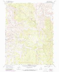
1968 Map of Rainbow
USGS Topo · Published 1987About this map
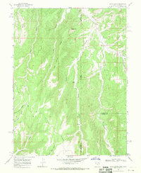
The Oil Springs Oil and Gas Field dominates the high, arid landscape of Uintah County in this late-1960s survey, updated with revisions from the early 1980s. The map centers on the Rainbow (Site), a location tied to the region's extraction history, situated near the distinctive Thimble Rock. This area of the Uinta Basin is defined by complex drainage networks, including the Center Fork Asphalt Wash and East Fork Asphalt Wash, which cut through the plateaus toward Evacuation Creek and Atchee Ridge. Industrial activity is evident through a network of trenches, an above ground pipeline, and scattered drill holes. Remote infrastructure like Kings Well and a Landing Strip illustrate the logistical demands of managing energy resources in this isolated corner of Utah.
Find a feature on this map
23 named features on this map. Tap any name to fly to it.
Don’t see what you’re looking for? This feature index may not catch every label — zoom into the map to look around manually.
Map Details
Editions of this 1968 Rainbow Map
2 editions found
Other maps of this area

1885 · East Tavaputs
USGS Topo · 1:250,000

1956 · Grand Junction
USGS Topo · 1:250,000

1959 · Grand Junction
USGS Topo · 1:250,000

1960 · Grand Junction
USGS Topo · 1:250,000

1962 · Grand Junction
USGS Topo · 1:250,000

1964 · Grand Junction
USGS Topo · 1:250,000

1965 · Grand Junction
USGS Topo · 1:250,000
1966 · Copper Canyon
USGS Topo · 1:24,000
1966 · Burnt Timber Canyon
USGS Topo · 1:24,000
1966 · Davis Canyon
USGS Topo · 1:24,000