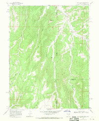
1966 Map of Davis Canyon
USGS Topo · Published 1970About this map
Atchee Ridge and the surrounding high country define this 1966 topographic survey of the borderlands between Uintah, Utah, and Rio Blanco, Colorado. The landscape is deeply incised by a network of drainages including Davis Canyon and Dragon Canyon, which served as natural corridors for early travel. The presence of an Oil Seep along Whiskey Creek in the southeastern quadrant points to the subterranean resources that would eventually drive regional development. Sparse water sources like Mud Spring and the perennial Evacuation Creek were critical waypoints for those navigating the ridge-and-canyon terrain. Numerous jeep trails crisscross the ridges, tracing paths through Rector Ridge and Indian Spring Ridge that followed the easiest grades of this isolated high desert environment before modern paved access was established.
Find a feature on this map
26 named features on this map. Tap any name to fly to it.
Don’t see what you’re looking for? This feature index may not catch every label — zoom into the map to look around manually.
Map Details
Editions of this 1966 Davis Canyon Map
2 editions found
Other maps of this area

1885 · East Tavaputs
USGS Topo · 1:250,000

1956 · Grand Junction
USGS Topo · 1:250,000

1959 · Grand Junction
USGS Topo · 1:250,000

1960 · Grand Junction
USGS Topo · 1:250,000

1962 · Grand Junction
USGS Topo · 1:250,000

1964 · Grand Junction
USGS Topo · 1:250,000

1964 · Texas Creek
USGS Topo · 1:24,000

1964 · East Evacuation Creek
USGS Topo · 1:24,000

1964 · Baxter Pass
USGS Topo · 1:24,000

1965 · Grand Junction
USGS Topo · 1:250,000