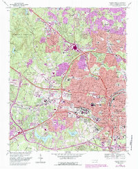
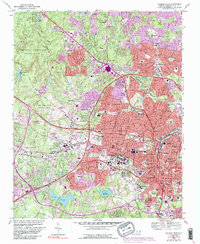
1968 Map of Raleigh West
USGS Topo · Published 1987About this map
North Carolina State University and the neighboring Meredith College anchor the institutional heart of this mid-century landscape. The map captures the westward expansion of Raleigh toward Cary, a period defined by the modernization of transportation and higher education. Suburban development is visible in the purple-shaded extensions near Tysonville and Method, while large open tracts are preserved in the William B Umstead State Park and the Carl Alwin Schenck Memorial Forest.
Find a feature on this map
112 named features on this map. Tap any name to fly to it.
Don’t see what you’re looking for? This feature index may not catch every label — zoom into the map to look around manually.
Map Details
Editions of this 1968 Raleigh West Map
6 editions found

Other maps of this area

1943 · Durham South
USGS Topo · 1:62,500

1943 · Raleigh
USGS Topo · 1:62,500

1951 · Raleigh
USGS Topo · 1:62,500

1951 · Durham South
USGS Topo · 1:62,500

1953 · Raleigh
USGS Topo · 1:250,000

1954 · Raleigh
USGS Topo · 1:250,000

1964 · Lake Wheeler
USGS Topo · 1:24,000

1964 · Garner
USGS Topo · 1:24,000

1964 · Garner
USGS Topo · 1:62,500
1967 · Wake Forest
USGS Topo · 1:24,000