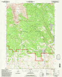
1991 Map of Ramshorn Peak
USGS Topo · Published 1997About this map
The Ramshorn and the prominent Ramshorn Peak dominate this landscape within the Shoshone National Forest, illustrating the high-altitude topography of Fremont County in the early 1990s. The map highlights the intersection of protected wilderness and early timber history, specifically at the site of the Fisher Tie Camp near Rainbow Lake. The northern portion of the sheet is occupied by the Washakie Wilderness, where drainages like Burroughs Creek and Poppie Creek carve through the basin.
Find a feature on this map
34 named features on this map. Tap any name to fly to it.
Don’t see what you’re looking for? This feature index may not catch every label — zoom into the map to look around manually.
Map Details
Editions of this 1991 Ramshorn Peak Map
This is the sole edition of this map. No revisions or reprints were ever made.
Other maps of this area

1905 · Younts Peak
USGS Topo · 1:125,000

1907 · Younts Peak
USGS Topo · 1:125,000

1955 · Thermopolis
USGS Topo · 1:250,000

1956 · Indian Point
USGS Topo · 1:24,000

1956 · Dubois
USGS Topo · 1:24,000

1956 · Esmond Park
USGS Topo · 1:24,000

1956 · Shoshone Pass
USGS Topo · 1:24,000

1956 · Ramshorn Peak
USGS Topo · 1:24,000

1956 · Snow Lake
USGS Topo · 1:24,000

1956 · Warm Spring Mountain
USGS Topo · 1:24,000