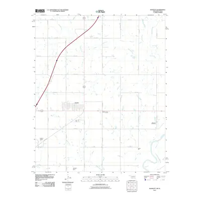
2010 Map of Randlett
USGS Topo · Published 2010About this map
Randlett serves as the central hub of this Southern Oklahoma landscape, situated just north of the Red River at the Texas border. The town's grid is defined by its proximity to significant petroleum activity, as evidenced by the Southwest Randlett Oil Field and the West Rabbit Creek Oil Field. The surrounding terrain is a network of drainage systems, with Deep Red Creek, West Cache Creek, and Rabbit Creek carving through the countryside. These waterways ultimately feed into the Red River, which forms a prominent, winding boundary at the bottom of the sheet. Local landmarks such as the Randlett Cemetery and Martin Hill provide specific points of reference for genealogists and local historians, while the Oknoname 033009 Dam indicates mid-century water management efforts. The grid of county roads, including Co Rd E1930 and Co Rd N2550, highlights the organized agricultural and industrial layout of the region.
Find a feature on this map
26 named features on this map. Tap any name to fly to it.
Don’t see what you’re looking for? This feature index may not catch every label — zoom into the map to look around manually.
Map Details
Editions of this 2010 Randlett Map
This is the sole edition of this map. No revisions or reprints were ever made.
Other maps of this area

1915 · Burkburnett
USGS Topo · 1:24,000

1918 · Buckburnett
USGS Topo · 1:31,680

1955 · Lawton
USGS Topo · 1:250,000

1957 · Burkburnett
USGS Topo · 1:62,500

1957 · Randlett
USGS Topo · 1:62,500

1962 · Chattanooga
USGS Topo · 1:62,500

1962 · Walters
USGS Topo · 1:62,500
1972 · Burkburnett
USGS Topo · 1:24,000
1972 · Thornberry
USGS Topo · 1:24,000
1972 · Charlie
USGS Topo · 1:24,000