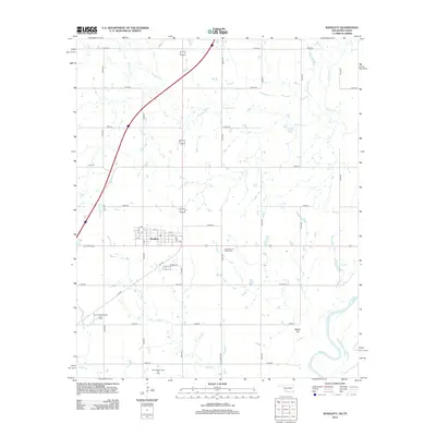
2012 Map of Randlett
USGS Topo · Published 2012About this map
Randlett serves as the central hub of this Southern Oklahoma landscape, where the town's grid is defined by streets from A Ave to F Ave and 11th St. The surrounding countryside is shaped by a network of drainage systems, including the southward-flowing Deep Red Cr and Rabbit Cr, which eventually meet the Red River along the southern border. This map captures the industrial and community landmarks of Cotton County, notably the West Rabbit Creek Oil Field and the Southwest Randlett Oil Field, indicating the area's continued reliance on petroleum extraction. Local heritage is further anchored by the Fairview Cem of Randlett, located east of the main town site, and the prominent elevation of Martin Hill overlooking the river valley.
Find a feature on this map
37 named features on this map. Tap any name to fly to it.
Don’t see what you’re looking for? This feature index may not catch every label — zoom into the map to look around manually.
Map Details
Editions of this 2012 Randlett Map
This is the sole edition of this map. No revisions or reprints were ever made.
Other maps of this area

1915 · Burkburnett
USGS Topo · 1:24,000

1918 · Buckburnett
USGS Topo · 1:31,680

1955 · Lawton
USGS Topo · 1:250,000

1957 · Burkburnett
USGS Topo · 1:62,500

1957 · Randlett
USGS Topo · 1:62,500

1962 · Chattanooga
USGS Topo · 1:62,500

1962 · Walters
USGS Topo · 1:62,500
1972 · Burkburnett
USGS Topo · 1:24,000
1972 · Thornberry
USGS Topo · 1:24,000
1972 · Charlie
USGS Topo · 1:24,000