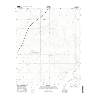
2016 Map of Randlett
USGS Topo · Published 2016About this map
Randlett serves as the primary hub of this landscape along the border of Oklahoma and Texas, where a grid of rural roads connects agricultural sections to the town's central streets. The geography is defined by a complex drainage system flowing toward the southern boundary, including the wide Red River and its various tributaries like Deep Red Cr and Rabbit Cr. These watercourses create natural variations in the terrain, such as the prominent Martin Hill located in the southeastern portion of the quadrangle.
Find a feature on this map
41 named features on this map. Tap any name to fly to it.
Don’t see what you’re looking for? This feature index may not catch every label — zoom into the map to look around manually.
Map Details
Editions of this 2016 Randlett Map
This is the sole edition of this map. No revisions or reprints were ever made.
Other maps of this area

1915 · Burkburnett
USGS Topo · 1:24,000

1918 · Buckburnett
USGS Topo · 1:31,680

1955 · Lawton
USGS Topo · 1:250,000

1957 · Burkburnett
USGS Topo · 1:62,500

1957 · Randlett
USGS Topo · 1:62,500

1962 · Chattanooga
USGS Topo · 1:62,500

1962 · Walters
USGS Topo · 1:62,500
1972 · Burkburnett
USGS Topo · 1:24,000
1972 · Thornberry
USGS Topo · 1:24,000
1972 · Charlie
USGS Topo · 1:24,000