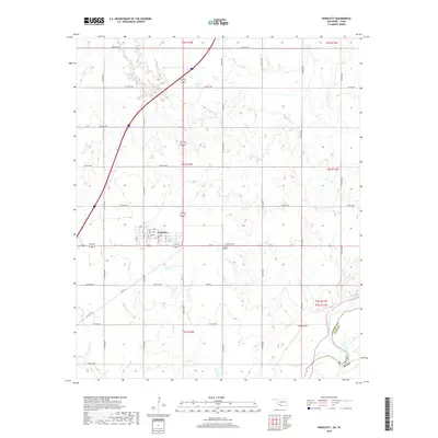
2019 Map of Randlett
USGS Topo · Published 2019About this map
Randlett serves as the central hub for this portion of southern Cotton County, situated just north of the meandering Red River border between Oklahoma and Texas. The town's grid is clearly defined by residential streets such as A Ave through F Ave and 5th St to 12th St, reflecting its role as a local crossroads. Just east of the settlement lies the Fairview Cem of Randlett, a key landmark for genealogical research. The surrounding landscape is shaped by the drainage patterns of Rabbit Cr, Deep Red Cr, and W Cache Cr, which flow through the section lines of the Public Land Survey System. To the southeast, Martin Hill rises above the river bottomlands, marking a distinct elevation point in the primarily agricultural terrain that spans across t4s r12w and adjacent townships.
Find a feature on this map
46 named features on this map. Tap any name to fly to it.
Don’t see what you’re looking for? This feature index may not catch every label — zoom into the map to look around manually.
Map Details
Editions of this 2019 Randlett Map
This is the sole edition of this map. No revisions or reprints were ever made.
Other maps of this area

1915 · Burkburnett
USGS Topo · 1:24,000

1918 · Buckburnett
USGS Topo · 1:31,680

1955 · Lawton
USGS Topo · 1:250,000

1957 · Burkburnett
USGS Topo · 1:62,500

1957 · Randlett
USGS Topo · 1:62,500

1962 · Chattanooga
USGS Topo · 1:62,500

1962 · Walters
USGS Topo · 1:62,500
1972 · Burkburnett
USGS Topo · 1:24,000
1972 · Thornberry
USGS Topo · 1:24,000
1972 · Charlie
USGS Topo · 1:24,000