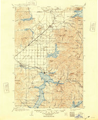
1903 Map of Rathdrum
USGS Topo · Published 1948About this map
Coeur d'Alene serves as a focal point at the turn of the century, positioned where the Spokane River exits the expansive Coeur d'Alene Lake. The map reveals a transition from the agricultural expanse of Rathdrum Prairie to the timbered heights of the Coeur d'Alene Mountains. Notable military and transport infrastructure is present, including the grounds of Fort Sherman and the vital industrial arteries of the Northern Pacific and Spokane International railroads. To the north, the waters of Spirit Lake and Twin Lakes sit below the peaks of the Kaniksu National Forest. The map documents numerous early settlements such as Athol, Post Falls, and Rathdrum, alongside smaller landings like Steamboat Landing on Pend Oreille Lake, illustrating the region's reliance on both rail and water for commerce and connection during this era of Idaho's development.
Find a feature on this map
100 named features on this map. Tap any name to fly to it.
Don’t see what you’re looking for? This feature index may not catch every label — zoom into the map to look around manually.
Map Details
Editions of this 1903 Rathdrum Map
4 editions found
Other maps of this area

1901 · Sandpoint
USGS Topo · 1:125,000

1901 · Spokane
USGS Topo · 1:125,000

1903 · Oakesdale
USGS Topo · 1:125,000

1903 · Rathdrum
USGS Topo · 1:125,000

1905 · Oakesdale
USGS Topo · 1:125,000

1909 · Cataldo
USGS Topo · 1:125,000

1911 · Cataldo
USGS Topo · 1:125,000

1911 · Priest Lake
USGS Topo · 1:250,000

1911 · Sandpoint
USGS Topo · 1:125,000

1913 · Priest Lake
USGS Topo · 1:250,000